
Seperator

Detect Critical Seafloor Anomalies—Faster, Smarter, and at Scale

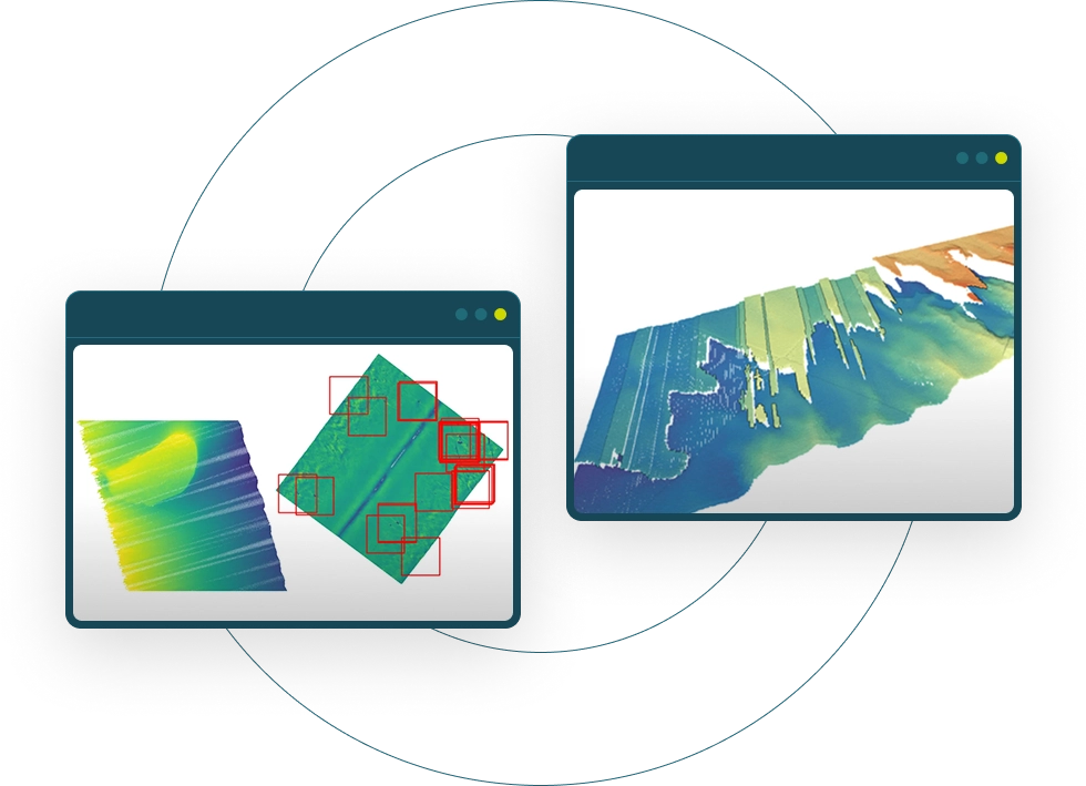
Automate the detection of seafloor anomalies (e.g. objects, shipwrecks, UXOs, cables, and more) directly from raw hydrographic datasets so your team can focus on what truly matters.

Seperator

What Sets Us Apart

Detect What Matters on the Ocean Floor

Modern offshore operations depend on fast, reliable, and scalable detection of anomalies and objects in the marine environment. Whether you're surveying for UXOs, wrecks, cables, or pipeline integrity, north.io’s Ocean Data Analytics helps you find what others miss.

Manual detection is slow and error-prone

Traditional workflows rely heavily on manual inspection of rasterized and aggregated datasets, missing critical detail from highest resolution raw sensor data.

Edge cases are often ignored

Objects on the boundaries of scan blocks or in sparse regions frequently go undetected.

Data overload

Modern sensors generate terabytes of complex point cloud data — making full review nearly impossible without automation and scalable computational resources.

Anomaly Detection Reinvented

Our solution automates anomaly and object detection directly on raw hydrographic datasets (MBES & SSS), combining spatial intelligence with modern big data approaches. The result? Faster discovery of what matters, with fewer false alarms.
All awards

High-Fidelity Seafloor Analysis

We process hydrographic data at the maximum available resolution, directly from raw sensor outputs, to preserve fine-scale geometry and material characteristics often lost in simplified or aggregated rasterised elevation models.

Adaptive Pattern Recognition

Our solution learns the natural variability of the seafloor and automatically identifies features that diverge from expected patterns— enabling fast, reliable anomaly detection at scale.

Detail-Rich Spatial Processing

Survey areas are analysed in spatially aware, overlapping segments that ensure no critical feature—such as wrecks, UXOs, or infrastructure—is missed due to boundary effects or data sparsity.

Multi-Dimensional Anomaly Scoring

We combine multiple dimensions of indicators to pinpoint true anomalies while minimising false positives—enhancing decision-making in offshore survey, inspection, and clearance missions.

Automated detection

See What Others Miss Beneath the Surface

Experience how automated anomaly detection accelerates offshore decision-making—from survey to action. No more guesswork, no more blind spots.
talk to us
Automated detection
01

Ingest and Interpret Complex Seafloor Data

02

Break Down the Survey Area into High-Resolution Segments

03

Extract Meaningful Patterns from the Seafloor

04

Learn and Generalise What ‘Normal’ Looks Like

05

Score and Validate Potential Anomalies

06

Visualise Results for Fast, Informed Decisions

Our Approach

Why It Matters

Glowing Dot
Fast Forward

Faster Decisions

Automated detection means your team spends less time scanning and more time acting.
Glowing Dot
Fast Forward

High Precision

Ingesting the raw sensor data,  the detection can be done on the highest resolution possible — ideal to detect even small anomalies. 
Glowing Dot
Fast Forward

Scalable for Big Data

Works across terabyte-scale MBES and SSS datasets without losing resolution or context.
Glowing Dot
Fast Forward

Built for the Offshore Industry

Tailored to hydrographic workflows, environmental uncertainty, and the need for evidence-based decision-making.
Seperator

FAQ

Frequently Asked Questions

Dot FAQ

What sensor data formats do you support?

We support 40+ formats including MBES (.ALL, .S7K), SSS (.XTF), SBP (.SEGY), point clouds (.LAS, .XYZ), raster/vector (GeoTIFF, SHP).
Dot FAQ

How does this differ from standard DEM-based workflows?

Unlike digital elevation model (DEM)-based tools, we don’t rely on pre-rasterised elevation models. Instead, our solution analyses raw point cloud data—preserving full spatial, structural, and material detail. This means higher detection accuracy, especially in areas with sparse data or subtle anomalies.


Dot FAQ

Can I use this with existing survey data, or do i need new acquisitions?

Absolutely. You can upload historical survey data and immediately gain new insights. Many clients detect overlooked anomalies in previously analysed datasets using our advanced analytics.
Dot FAQ

How do I get started?

Simply schedule a demo with our team. We’ll show you how the platform works, review your data needs, and guide you through onboarding—whether you're exploring a single project or integrating it into long-term workflows.

News

Further Reading

03.08.2026

Eliminating the High Cost of Hindsight

How Near Real-Time Processing Can Transform Offshore Survey Whether mapping the seabed for offshore wind development, inspecting subsea assets, or ...
Read more
28.07.2026

From Data Gaps to Audit-Ready Offshore Operations

How Near Real-Time Processing Can Transform Offshore Survey The offshore industry is entering a new era where data quality is no ...
Read more
28.07.2026

The Changing World of Geoscientists and Ocean Data

“The energy transition is going to need geoscientists. Almost every kind of renewable energy or net zero initiative you can ...
Read more

Features & Awards

Awards northio
About us

Newsletter

Get the latest updates on north.io’s topics and events.