KIMERA
Artificial Intelligence for Seabed Mapping and Marine Spatial Planning
The Project KIMERA
Artificial intelligence for seabed mapping and marine spatial planning
Marine spatial planning, including designated utilization and protection areas, must be established to guarantee the protection of the ocean while at the same time exploiting it economically. Though essential, marine spatial planning is faced with the sparse data basis of a largely unexplored deep sea.
North.io is therefore developing a software tool to transfer the selectively available research findings to the deep sea in a targeted manner. The tool will link research findings and expert knowledge with available seafloor data, thus enabling the training of an artificial intelligence (AI) that is to be developed as part of the KIMERA project ("Artificial intelligence for mapping the seabed and marine spatial planning").
This way, the KIMERA project is also working towards the UN Sustainable Development Goal 14 “Life below water”, which aims to secure the long-term productivity of the ocean and protect marine ecosystems and their important climate functions. Negative impacts on biodiversity and underwater habitats due to the economic use of the ocean, e.g. through fishing, sand extraction or tourism, are already measurable today. Effective spatial planning is becoming increasingly urgent against the backdrop of another potential industry, deep-sea mining. The need for deep-sea mining is driven by the ever-increasing demand for critical metals such as copper, cobalt and nickel. However, possible relevant sources of raw materials in iron manganese nodules and so-called "polymetallic massive sulphides" are hosted in the deep sea, which has been largely untouched and little explored, so far.
Four central maritime use cases will be considered over the course of the project, from 1 January 2022 to 31 December 2024: Internet of Underwater Things (IoUT), Offshore Wind Energy, Munitions in the Sea and Biological Climate Protection.
- Internet of Underwater Things (IoUT): Data-driven underwater technologies and sensor networks are central to the future digital blue economy. The aim is to develop sensor technologies that capture a digital twin of the underwater world in real time and create Gaia-X-compatible structures for data processing. A feasibility study at Fraunhofer IGD's Ocean Technology Campus is driving this project forward.
- Offshore Wind Energy: Offshore wind farms are crucial for climate neutrality. Marispace-X is developing solutions for collaborative data collection and efficient asset handling. The aim is to create data-driven applications and trusted data spaces to improve the efficiency of offshore wind farms. This includes tools for data collection and analysis as well as empowering end users for long-term data management.
- Munitions in the Sea: There are over 1.6 million tonnes of old munitions in German waters, which requires new, intelligent ways of analysing and managing data. The use case strives for improvements through cloud, edge and fog computing to make munitions clearance more efficient. This includes the integration of intelligent analyses in a secure cloud environment and the Gaia-X-compliant implementation of identity and trust services.
- Biological Climate Protection: Marine plants have a high CO2 storage capacity, and the use case aims to determine and optimise the CO2-saving potential of macrophytes. The aim is to improve the CO2 storage capacity of the oceans through new analysis methods and AI-based predictions. This includes the use of sensor fusion from optical remote sensing and acoustic underwater data.

Five central maritime use cases will be considered over the course of the project, from 1 January 2022 to 31 December 2024: Internet of Underwater Things (IoUT), Offshore Wind Energy, Munitions in the Sea, Biological Climate Protection, and Critical Infrastructure:

Project Specs
- Timeframe: September 1, 2023 - August 31, 2026
- Funding: €683,000
- Goal: The KIMERA project aims to develop AI for mapping and marine spatial planning in the deep sea.
Project Summary
The KIMERA project integrates research findings with seafloor data to create predictive maps, supporting the designation of marine protected and use areas. This initiative addresses biodiversity impacts from activities like fishing and mining, driven by the demand for critical metals. Led by GEOMAR and north.io, the project supports UN Sustainable Development Goal 14 by ensuring the long-term productivity and protection of marine ecosystems. The final AI models will be integrated into TrueOcean for practical application.
Funding
The KIMERA project is funded by the Staatskanzlei Schleswig-Holstein.
Our Contribution
Over the next three years, the KIMERA project will develop an AI to create predictive maps for spatial planning in the deep sea. These maps will provide a data-supported and knowledge-based basis for the urgently needed designation of marine protected areas and potential areas of use. Under the leadership of the GEOMAR – Helmholtz-Center for Ocean Research Kiel, north.io GmbH will help with data collection and handling, as well as the training and verification of AI algorithms. In the final step, the trained AI models will be integrated into TrueOcean and made available.
KIMERA Consortium
Associated Partners
OffCon GmbH Quality Positioning Services B.V. (QPS) Siemens Gamesa Renewable Energy GmbH & Co. KG
Wallaby Boats GmbH WINDEA Offshore GmbH & Co. KG Society for Maritime Technology e.V. IHK Schleswig-Holstein
TransMarTech S-H GmbH Labs Network Industrie 4.0 e.V.
Fraunhofer High-Performance Centre Sustainable Subsea Solutions (LZ S3) Maritime Cluster Northern Germany
Ministry of Energy, Agriculture, Environment, Nature and Digitalisation SH Ocean Data Alliance Ørsted Wind Power A/S
thyssenkrupp Marine Systems GmbH (with affiliated company ATLAS Elektronik GmbH)
Institute for Technical Research of the State of Sao Paulo - Braziil (IPT Brazil) SINTEF Digital SINTEF Ocean AS
K.U.M. Umwelt- und Meerestechnik Kiel GmbH SeaAhead BlueTech Innovation SatRevolution
Gabler Maschinenbau GmbH (with affiliated company develogic GmbH)
Ensuring the long-term productivity of the ocean and protecting marine ecosystems, central to UN Sustainable Development Goal 14: Life Below Water, is essential. Economic activities like fishing, sand extraction, and tourism are harming biodiversity and underwater habitats.
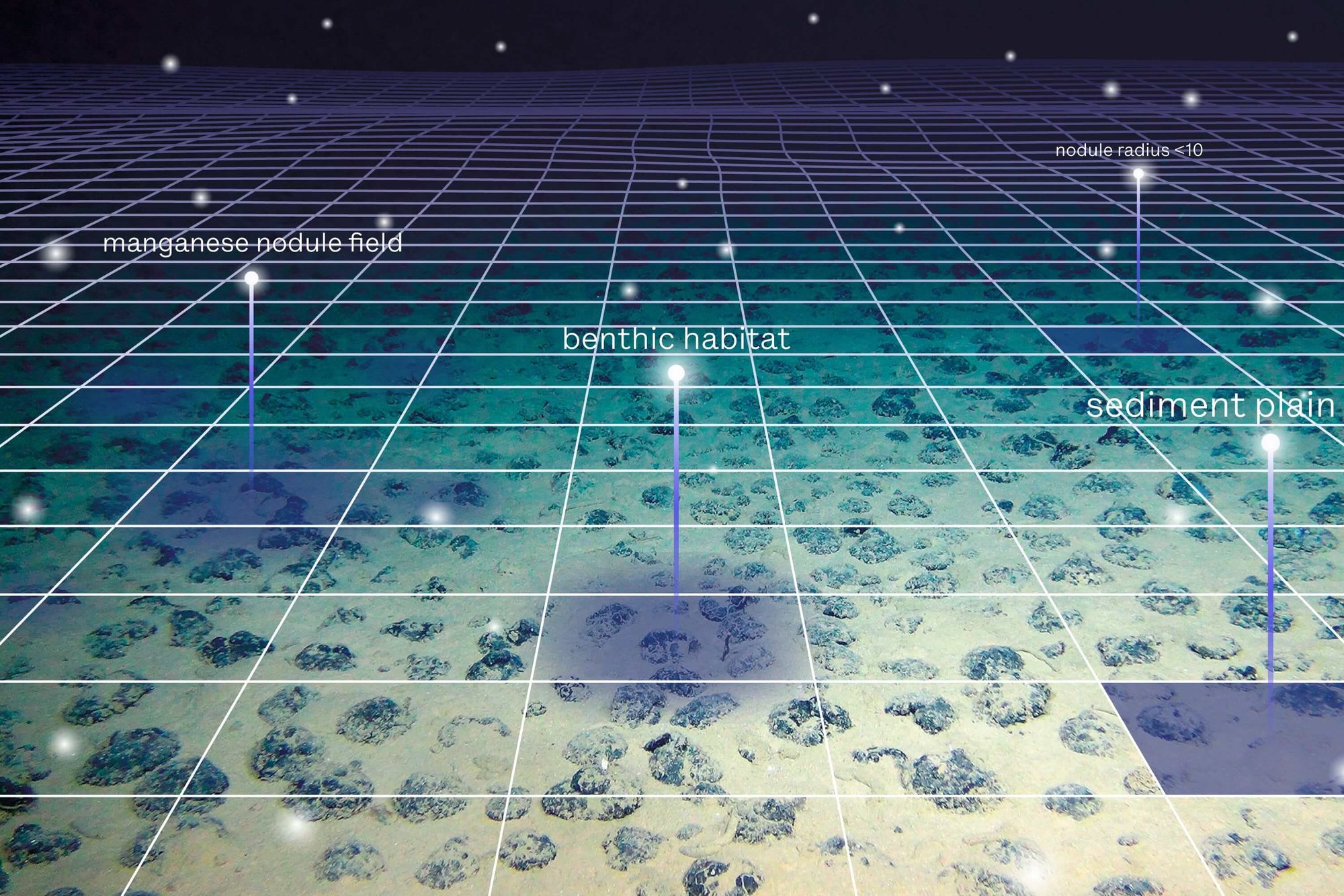
Simultaneously, there is increasing interest in deep-sea resources for critical metals (e.g., copper, cobalt, nickel) vital for energy and mobility transitions. These metals are found in iron manganese nodules and polymetallic massive sulphides in largely unexplored deep-sea areas. Effective spatial planning aligned with Goal 14 is necessary to utilise these resources sustainably. However, this is hindered by our limited knowledge of the deep sea.
Over three years, the KIMERA project aims to create an AI to extend habitat and raw material research findings to the entire deep sea in a data-based, controlled manner. The resulting predictive maps provide a crucial basis for the planning and designation of marine protected areas and potential areas of utilisation. Led by GEOMAR Helmholtz-Centre for Ocean Research Kiel, north.io GmbH assists in data collection and AI development.

Image source: GEOMAR Helmholtz-Centre for Ocean Research Kiel