Huge Data Volumes
Sensors with higher resolution generate ever larger data sets, leading to bottlenecks.
Automate and accelerate your ocean big data workflows beyond desktop limits with a powerful, cloud-native engine.
Organisations collecting ocean big data face growing data velocity and are limited by
outdated desktop-based methods.
Sensors with higher resolution generate ever larger data sets, leading to bottlenecks.
Desktop software is not designed for big data and limited by hardware resources.
From file validation to merging, everything requires repetitive manual steps.
No built-in tools for automatic validation, flagging, or cleaning reduce trust in results.
Manual and repetitive workflows take days or weeks to process datasets.
Only highly specialized personnel can operate complex legacy software.
Our engine utilises scalable architectures to apply parallel high-performance cloud computing to complex raw underwater sensor data: insights created in seconds.
Process dozens of raw underwater datasets across multiple workflows simultaneously. No need to wait for one batch to finish before starting the next.
Drag, drop, and queue complete folders of files. The engine handles multi-step processing with logic tailored to each activity.
Our engine understands your data—from MBES, SSS to LIDAR—and intelligently provides relevant algorithms for each file. No manual matching required.
Get started fast with top activities per sensor type:
MBES: Beam footprint, coverage, bathymetric features
SSS: Signal-to-noise ratio, signal footprint, coverage
LIDAR: Point density, coverage, topographic features
You don’t need to be a scripting expert. Our UI guides you through creating complex pipelines without crashing your system.
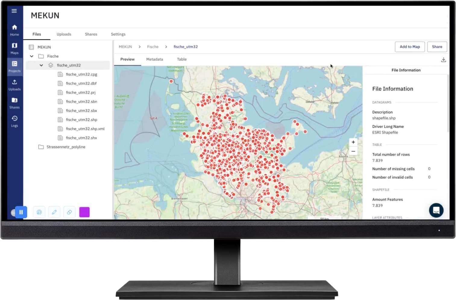
Watch how easily you can set up an entire ocean big data processing workflow.
Upload your files, select the activity, and let the engine do the rest.
Transform your ocean big data workflows with faster and scalable cloud-computing.
Leverage cloud resources when you need them. No need for intensive hardware investments.
Process dozens of files in parallel. Turn raw data into actionable outputs in hours, not days.
Advanced processing methods yield razor-sharp outputs, even on Side Scan Sonar. Perfect for detecting small objects like torpedoes or anchors.
Export data in standard, open formats (GeoTIFF, Geojson, Geoparquet, Las/Laz etc. or share them as WMS) and stay in control of your own information.
Combine the power of geospatial analysis with geophysical processing to understand what lies beneath the ocean's surface.
Our Ocean Big Data Processing Engine was designed for scalable, distributed underwater data processing. Unlike traditional desktop, we enable data processing at the oint cloud level using raw data: preserving accuracy and creating more insights.
At its core, the Ocean Big Data Processing Engine is powered by Apache Spark, the industry-standard framework for distributed, parallel computation. This enables fast processing of massive data volumes across multiple nodes simultaneously, turning hours of work into minutes.
The Ocean Big Data Processing Engine runs in containers orchestrated by Kubernetes, ensuring high reliability, workload balancing, and dynamic scalabilit. Whether you need to process a single file or an entire survey campaign.
The engine's build-in geointelligence automatically detects your input data type (e.g., MBES, SSS, SBP) and provides matching algorithms. Workflows are built based on file format, metadata, and analysis goals, so you stay focused on outcomes, not configurations.
Instead of converting raw sensor data into rasters, the Ocean Big Data Processing Engine performs computations directly on raw and unified point cloud data (Apache Spark & Parquet). This approach avoids loss of critical detail during early rasterization.
Using Apache Parquet, a columnar data format, the Ocean Big Data Processing Engine reads and writes large datasets efficiently, allowing selective access to necessary data without loading entire files. This results in 10x-100x faster read/write speeds than flat formats like CSV.
Rather than relying on expensive IT-infrastructure and servers, the Ocean Big Data Processing Engine optimally distributes tasks across cloud compute nodes. This design dramatically improves reliability, reduces hardware costs, and allows workloads to scale with your project needs.
Together, these technologies form the backbone of a highly automated, cloud-native ocean data engine—purpose-built for today’s marine professionals. Whether you’re processing multibeam surveys, sidescan sonar, or seismic profiles, the Ocean Data Processing Engine gives you speed, accuracy, and flexibility—without compromise.
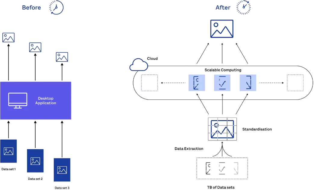
Stop wasting time with crashing software and manual processing.
Let's discover how to accelerate ocean data processing and generating insights in seconds.
Experience the future of ocean data processing.
No. The engine is fully cloud-native and runs in your browser. There's nothing to install, configure, or maintain locally.
We support a wide range of ocean data types—Multibeam (MBES), Side Scan Sonar (SSS), LIDAR (POINTCLOUD), and generic formats like GeoTiff, XYZ, LAS, LAZ, and more. The engine automatically selects relevant algorithms based on your uploaded files.
We use Apache Spark for distributed processing and Kubernetes for smart resource scaling. This allows you to run multiple workflows in parallel—across hundreds of files—without being limited by local hardware.
Not at all. Unlike traditional systems that rely on rasterizing data early, we process everything natively at the point cloud level—preserving precision and granularity for better results.
Yes. You can export to open-standard formats such as GeoTIFF, SHP, LAS, GeoJSON, GeoParquet, or share them as WMS, ensuring full interoperability and no vendor lock-in.